Funky Texas Traveler

Be a traveler, not a tourist. Dig deeper, learn more.

  • About
  • Attitude
    • Camping
    • How to survive and thrive when your reputation tanks – Life lessons from Mark White
    • 8 steps to unexpected success from Texas Fruitcake Queen
    • 5 Road Trip Luxuries You Shouldn’t Travel Without
    • 5 steps to grow your adventure outlook!
    • Smart Souvenir Shopping
    • Have Fun Flying – Southwest Airlines
    • Strange Places to Stay
    • Start a Party- Galveston Mardi Gras
    • We have only now!
    • Lifetime of fun at National Parks
    • Surviving Hurricane Harvey flooding – 8 practical ways to cope
    • Life’s Detours
      • Cancer
        • Breast Cancer – Think you might have it? What happens now?
        • Breast Cancer. 5 steps to take before treatment
        • My Breast Cancer Experience – A Month at MD Anderson Cancer Center
  • People
    • How to survive and thrive when your reputation tanks – Life lessons from Mark White
    • “John Cody” movie
    • 8 stupidly-simple ways the Texas Fruitcake Queen built big success
  • Places
    • Texas
      • Central Texas
        • Guadalupe River
          • Guadalupe River Luxury
          • Guadalupe River Rustic Weekend
          • Guadalupe River Tubing & Camping on River Road
        • Llano
          • Wedding haunted by Bonnie & Clyde memories
        • San Antonio
          • San Antonio Beyond the Alamo
          • Alamo City Eats
        • Schulenberg/Flatonia/Dubina
          • 8 stupidly-simple ways the Texas Fruitcake Queen built big success
      • Coastal Texas
        • Baffin Bay
          • King’s Inn – Loyola Beach, Texas
        • Boca Chica
        • Houston
          • Houston’s Best Bars and Restaurants for Sports Fans
        • Galveston
          • Galveston – Frozen in time
          • Galveston Mardi Gras
          • Big Ass Crawfish Bash
        • Port Aransas
          • Port Aransas – Best Beach Town in Texas
          • Port Aransas Farley Boat Works damaged by hurricane
          • Port Aransas post Harvey
        • South Padre Island
      • West Texas
        • Alpine
        • Big Bend National Park
          • 5 Reasons to visit Big Bend National Park
        • El Paso
        • Fort Davis
          • Frontier faith in far West Texas – Bloys Cowboy Campmeeting
        • Marfa, Texas
        • Terlingua Ghost Town
        • Wander West Texas
    • Not Texas
      • California
        • Yosemite or Yellowstone National Park
      • Louisiana
        • New Orleans
        • St. Martinville
          • Cajun Country
      • Minnesota
        • Boundary Waters BWCA
      • Mississippi
        • Meridian
      • Montana
        • Yosemite or Yellowstone National Park
      • New Mexico
        • Deming and Columbus
      • North Carolina
        • Asheville
        • Blue Ridge Parkway
      • Pennsylvania
        • Gettysburg
      • Utah
        • Yosemite or Yellowstone National Park
      • Virginia
        • Blue Ridge Parkway and Skyline Drive
      • Wyoming
        • Yosemite or Yellowstone National Park
    • Not Texas or the US
      • Belize
      • Caribbean
        • How hurricane hijacked Caribbean sailing vacation in BVI
      • Canada
        • Boundary Waters BWCA
    • Road Trip
  • Events
    • Festivals
      • Faith
        • Frontier faith in far West Texas – Bloys Cowboy Campmeeting
      • Food
      • Holiday
      • Music
    • Texas Country Music Cruise
  • Start A Blog
    • Help me understand blog talk!!!
    • How to start your blog
  • Recommendations
    • Food
      • Houston’s Best Bars and Restaurants for Sports Fans
      • King’s Inn – Loyola Beach, Texas
    • Transportation
      • Southwest Airlines Boarding Game

Jul 09 2016

Road Ramble 2016 – The Blue Ridge Parkway and Skyline Drive

blue-ridge-parkway-sign-300x225 Road Ramble 2016 - The Blue Ridge Parkway and Skyline Drive
Image by Ken Lund via Flickr. CC by 2.0

After the three-day layover in Asheville, Mary Ann came along for the seven to nine hour drive to Maryland to see some more invasive Texans who now called Maryland home.  Because our friends were teachers and had graduation ceremonies on Friday, we waited until noon on Friday to leave Asheville.  That would  break up the trip and get us to Gaithersburg on Saturday afternoon.  We also got the opportunity to  scare some poor guy  in a Motel 6  outside Roanoke when M.A. and I misread our key card and tried to break into his hotel room. Fun and games on the road.

We wanted to travel at least part of the way along the Blue Ridge Parkway.  Combined with the Skyline Drive in Virginia, these ridge roads would take us over 490 miles in the right direction but still left us 80 miles shy of our final destination. Figuring on top speeds of 45 mph and frequent 25 mph sections, using the BRP for the entire trip could take all weekend.  We’d jump on and off, using I-81 to make up some time.   Our plan was to pick up the Blue Ridge Parkway north of Asheville to avoid the Biltmore congestion.  That decision looked good on paper.


We left Asheville on I-40 and picked up US-70 at Old Fort.  At Pleasant Gardens, we turned onto Highway 80 and started to spiral up for the next several miles.  It was like driving inside a forested silo as far as the line of sight went.  We had exchanged the congestion in Asheville for a path of no return – no  turn-arounds or shoulders and very few cars coming the other direction.  Mary Ann swallowed a Dramamine.  My fingers were starting to cramp from tightly gripping the steering wheel.   There was a reason AAA had not taken us this way on our Triptik.

Marie-François_Firmin-Girard_-_Ulysses_and_the_Sirens_1868-1-300x209 Road Ramble 2016 - The Blue Ridge Parkway and Skyline Drive
Painting by Marie Francois Firmin Girard

Coming out of another seemingly endless blind curve, we came to an intersection. A pullover beckoned like a Ulysses siren from across the road.  Mary Ann and I swerved in, getting withering  looks from two outdoor types in an SUV enjoying their moment with nature.  Mary Ann jumped out of the car and gulped in fresh air.  I shook and wiggled my fingers and did some moving in place exercises to get blood flowing after a permanent clinch of all voluntary muscles for the last thirty minutes.    Our “Texas” license plate confirmed for our neighboring SUV-ers that the flat-landers had arrived.  Finally, we saw the sign.  We had made it onto The Blue Ridge Parkway.

18106700281_0a6bc1885f_n-300x225 Road Ramble 2016 - The Blue Ridge Parkway and Skyline Drive
Appalachian National Scenic Trail Survey Marker – BlueRidgeParkwayNPS

Originally called the Appalachian National Scenic Highway, the BRP was started in 1935 under Franklin D. Roosevelt using mostly private contractors. Various New Deal public works agencies did some of the work, including the Works Progress Administration (WPA) for some roadway construction, the Emergency Relief Administration for landscaping and developing recreation areas and the Civilian Conservation Corps (CCC) for  roadside cleanup and plantings, grading slopes, and doing some improvement on adjacent fields and forest lands. During World War II, conscientious objectors in the Civilian Public Service  took over from CCC and the young men who were fighting in Europe and the Pacific.

According an article called “Designing the Parkway” in the Blue Ridge Parkway Directory and Travel Planner, “Overall, the Parkway was to reveal the charm and interest of the native American countryside as the designers perceived that to be.  Log cabins, and barns, rail fences and pioneer ways were looked upon much more favorably than some of the more modern presentations of America that had already found their way into the mountains in the 1930s and 40’s.” The Parkway’s construction created needed jobs but there were losers in the project too – displaced residents and landowners and farmers who faced new regulations, including how crops could be transported.  Land use and development was limited to agriculture and no commercial traffic could use the Parkway so equipment, materials and produce had to travel on side roads.

Once again, the Cherokee were affected. This time, it was the eastern band of Cherokee.  The Parkway was to be built through their lands.  Perhaps learning from past dealings with the US government, the Cherokee refused to give up right of way until 1940 when they negotiated payment for their land.  They also demanded and got the state to build a regular highway through the Soco Valley.  It is now part of US 19.

Most of the Parkway project was completed in 1966 except for a portion of the  area we were traveling.  This stretch included the Linn Cove Viaduct and Grandfather Mountain and  didn’t open until 1987, fifty-two years after the start of construction.

black-mountain-overlook2-jpg Road Ramble 2016 - The Blue Ridge Parkway and Skyline Drive
Black Mountain Overlook

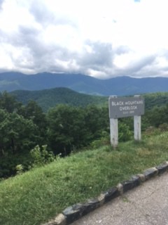
We’d entered the Blue Ridge Parkway at Buck Creek Gap at Mile 344.  Every mile or three was an overlook – Black Mountain, Three Knobs, Deer Lick Gap.  Those were three to stop at before we’d even gotten as far as Little Switzerland off to the east at Mile 334. Little Switzerland was built in 1910, a very old world mountain lodge with cottages, restaurants, tennis and golf.  It presented a jarring contrast between the displaced mountain folk and the people who could vacation at Little Switzerland in the early part of the century.  But we were here for nature not comfort so we drove past the resort and  headed for Linville Falls.

The Linville River starts on the steep slopes of Grandfather Mountain and descends almost 2000 feet through a rugged gorge, prompting the Cherokee to call the river “Eeseeoh” or “river of cliffs.”  To get industrialist John D. Rockefeller to pick up the tab for the Linville Falls property, he was treated to an al fresco lunch to take in the grandeur.  The picnic was spread out in view of the falls and coincidentally close enough to hear the noise from sawmills diligently deforesting the slopes  like a bevy of beavers.  The picnic plan worked perfectly.  As we snacked and visited with picnickers along the shaded river at the Linville Falls visitor’s center, we raised a Yeti rambler to ole’ John D and his gracious gift.

driving-view-of-brp-300x200 Road Ramble 2016 - The Blue Ridge Parkway and Skyline Drive
Image by BlueRidgeParkwayNPS

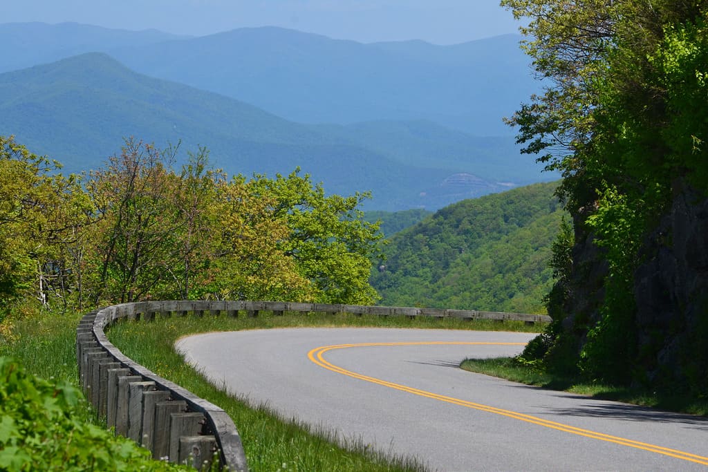
Our  dilemma how frequently to stop at a visitor center or overlook on the Blue Ridge Parkway.  Each stop gave you a chance to pause and savor the scenery but a drive provided an unfolding view of both the majestic surroundings and the virtuoso design the planners and builders of the Parkway had achieved.  The Parkway was meant to “lie gentle on the land” and this intention was well met.   Bridges merged into the roadways with continuous shoulders of grass.  There was no side stripping on the road to create a hard line between the pavement and natural setting. Many times, the long and distant views opened up to delight just as you come out of a curve.  Because there are few straight lines in nature, on the Parkway, one curve flowed into the next like a river.  Fences are made of stone, wood or different combinations to blend into the fields and forests.  “Look!” was an overused word that afternoon in our car.  How could you take it all in?  I now see why the Parkway is a destination to visit often, slowly moving your camping base a few miles down the road every year to explore it piece by lovely piece.

Linn_Cove_Viaduct-300x225 Road Ramble 2016 - The Blue Ridge Parkway and Skyline Drive
Linn Cove Viaduct by uploader Bill Pearmain at English Wikipedia
At Mile 304, we started across the Linn Cove Viaduct, whose completion had been delayed twenty years after the rest of the Parkway opened to the public.  Architects and engineers were struggling with how to preserve the fragile environment on the slopes of Grandfather Mountain.  According to the National Park Service, the dilemma was “how to build a road at an elevation of 4,100 feet without damaging one of the world’s oldest mountains. National Park Service landscape architects and Federal Highway Administration engineers agreed the road should be elevated, or bridged, where possible to eliminate massive cuts and fills.”

“The result: the Linn Cove Viaduct at milepost 304.6, the most complicated concrete bridge ever built, snaking around boulder-strewn Linn Cove in a sweeping “S” curve”.  Construction began in 1979 and the challenges faced and overcome where massive.  For a complete history of building this “missing link” on the Parkway, read more at The National Park Service   Once again, the Parkway builders had created a compelling compromise to preserve a scenic treasure.

Cones_Mansion_near_Blowing_Rock_N.C._1911-300x193 Road Ramble 2016 - The Blue Ridge Parkway and Skyline Drive
Manor postcard – By The Brown Book Co., Asheville, North Carolina – Beinecke Rare Book & Manuscript Library [1], Public Domain
We had decided to jump off the Parkway after Blowing Rock and head through Boone to get to the interstate.  Due to our unnerving experience getting onto the Parkway, we needed to plan ahead and find a bathroom before committing to another unknown mountain exit road.     We saw a sign for Moses H. Cone Memorial Park and a visitor center so we turned off the Parkway and headed into the woods.  We were expecting a generic rustic park office manned by rangers with picnic tables under the trees.  Here we encountered one of those fortunate detours that can define your whole experience of the parkway.  Suddenly we were transported from Appalachia to what seemed like Austria and the Von Trapp estate in the “Sound of Music.”  Moses H. Cone’s Flat Top Manor rivaled George Vanderbilt’s Biltmore in Asheville but was built in this soothing ,isolated, alpine setting.

long-stop-linda-a-manor-house-unedited-300x225 Road Ramble 2016 - The Blue Ridge Parkway and Skyline Drive
Linda savoring view from Flat Top Manor
looking-at-lake-a-manor-225x300 Road Ramble 2016 - The Blue Ridge Parkway and Skyline Drive
Viewing the lake from Flat Top Manor porch

Moses, a textile entrepreneur, founded a company that became a major supplier of denim to the Levi Strauss and Company.  Using the profits from the excellent timing of his venture, Moses and Bertha Cone began acquiring land in the 1890s in the Blowing Rock area for his house.  Reporters of the time nicknamed him and his blue blood counterpart “Farmer Cone” and “Farmer Vanderbilt”. The total estate had a twenty-three  room mansion (now re- purposed as an  art center), twenty-five miles of carriage lanes, livestock, gardens, and an extensive orchard plus a number of other buildings including a bowling alley (since torn down).  The manor house is at an elevation of 4500 feet and looks down on an azure  lake.  Its location is ringed by mountains including the one that gave the house its name – Flat Top Mountain.  Because of its location and the working nature of Moses Cone’s estate, it was easier to believe that a family had happily lived and prospered here.  On my visit to the Biltmore, living day to day in that elaborately furnished mausoleum seemed inconceivable.

We left the BRP right after the Cone Manor and headed west to Boone, NC.  Boone was named after Daniel, the frontiersman and 60’s TV show character.  The town was settled by some of his nephews.  It is the home to Appalachian State University and it may have been graduation at the college because all the sidewalks downtown and around the school were swarming with what looked like proud parental units.  Railroad enthusiasts visit Boone to see the narrow gauge East Tennessee and Western North Carolina Railroad (nicknamed “Tweetsie”) which operated until the flood of 1940.  Mary Ann was interested in Boone because it apparently had a reputation akin to Roswell New Mexico for UFO’s and alien abductions.  The epicenter of all the interest is Brown Mountain and its mysterious lights.  According to BrownMountainabductions.com, people have been disappearing after seeing the lights for centuries, including twenty-seven people vacationing at a popular campground in October 2011. How did I not read about that?   The only thing getting abducted during our visit was a bag of peaches from a truck farmer in the parking lot of a hardware store.  We spirited them away to a Motel 6 in Roanoke for vivisecting.

Skyline_Drive_Virginia_map.svg-300x177 Road Ramble 2016 - The Blue Ridge Parkway and Skyline Drive
Skyline Drive map by Mr. Matte

On Saturday morning we headed up Interstate 81 until we tired of the fast pace. Leaving the freeway near New Market, we drove east on US 211 , winding  along and over the Massanutten Mountain and across the South Fork Shenandoah River.  The road enters the Blue Ridge Mountains in the Shenandoah National Park.   At Thornton Gap, we connected for a short time with Skyline Drive.  Skyline Drive takes up where the Blue Ridge Parkway runs out.  It travels 109 miles along the Shenandoah National Park and is another legacy of the Works Progress Administration (viva WPA!), begun in 1930 and finished in 1939.

We didn’t realize until we read the Shenandoah National Park website that we were “driving along one of the most significant tools the Confederacy utilized during the American Civil War.”  According to the website, “Throughout the four years of the Civil War (1861-1865), Confederate armies frequently used the Blue Ridge Mountains as a natural screen to conceal the movement of troops from Union forces. Because of the southwest-northeast orientation of the Shenandoah Valley west of the Blue Ridge, Confederate armies marching down the Valley naturally moved toward a position from whence they could threaten the northern cities of Washington and Baltimore, while Union armies marching up the Valley were forced to move farther away from the Confederate capitol of Richmond.”

Stonewall_Jackson_by_Routzahn_1862-213x300 Road Ramble 2016 - The Blue Ridge Parkway and Skyline Drive
General Thomas J. “Stonewall” Jackson by Nathaniel Routzahn (1822 – 1908), {{PD-US}}

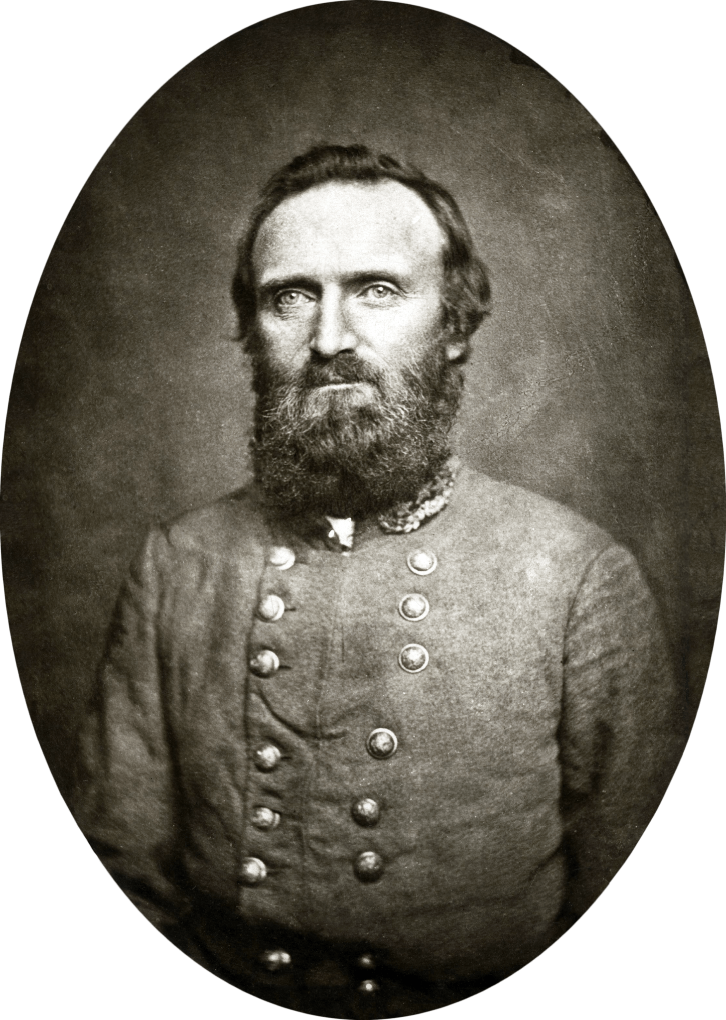
The confederate commander who made best use of the Blue Ridge in this area was the fervently religious General Thomas J. “Stonewall” Jackson. Using cover from the ridge and his knowledge of its gaps and valleys, he and his 17,000 men won five significant victories in the Valley campaign against a combined force of 60,000. Like most of us, Stonewall was a flawed but heroic ball of wax.  He was an instructor at the Virginia Military Institute and parts of his curriculum are considered timeless military strategy and still taught, yet Jackson was an unpopular teacher.  Peculiar in his personal habits, humorless and a hypochondriac, Jackson was at the same time revered by both free black men and slaves around his hometown of Lexington, Virginia.   According to historian James Robertson, “Jackson neither apologized for nor spoke in favor of the practice of slavery. He probably opposed the institution. Yet in his mind the Creator had sanctioned slavery, and man had no moral right to challenge its existence. The good Christian slaveholder was one who treated his servants fairly and humanely at all times.”   In the spring of 1862 his daring success in the Valley campaign made Jackson the most celebrated warrior in the Confederacy.  In May 1863, he was shot by Confederate pickets at the Battle of Chancellorsville, had his arm amputated and died eight days later.  His last words were, “Let us cross over the river, and rest under the shade of the trees.”  We were taking Stonewall’s heartfelt advice.


signature Road Ramble 2016 - The Blue Ridge Parkway and Skyline Drive

Filed Under: Blue Ridge Parkway, North Carolina, Places, Virginia · Tagged: Boone North Carolina, Flat Top Manor, Lin Cove Viaduct, Linnville Falls, Moses H. Cone, Skyline Drive, Stonewall Jackson

Jun 26 2016

Road Ramble 2016 – Asheville, North Carolina: June 12-15


After five days on the road, I was heading to a friend’s house in Asheville, NC.  I had driven Mary Ann and her aging dog to Asheville when she made her initial move four years ago.  She was BOI (born on Galveston Island) and had lived in the Montrose area of Houston during the forty years we have been friends.  Her move to North Carolina didn’t take the first time.  She returned to Houston a year later and stayed until the building boom in Montrose and its resulting traffic snarls convinced her to give Asheville another try.  Also, she was completely done with our heat and humidity.  She prayed on the decision and got an answer.

peden-house-cropped-300x169 Road Ramble 2016 - Asheville, North Carolina: June 12-15
Montrose home replaced with two townhomes

A young man knocked on the door of her 1930’s Peden Street bungalow and asked her what it would take to sell him her house.  She gave him a ridiculous figure, said she would only take cash, and wanted absolutely no closing costs.  Oh, and she couldn’t move for another six months.  He said fine and showed up a few days later with a contract and a check that cleared.  After years of budgeting and saving and just getting by, one of the most deserving people I know caught a huge break.


asher-lane-house-cropped Road Ramble 2016 - Asheville, North Carolina: June 12-15
New Asheville Home

Six months later, she was back in Asheville and buying a brand new house that looked a little like her Montrose craftsman home but without the peeling paint, sagging picket fence and mega mansions crowding in on it.  Asheville is growing like a weed or a cannas lilly, depending on your perspective.  Her subdivision was once farmland along the edge of the French Broad River.  It is so new that when I tried to find her house with my new I-phone SE GPS, I was instructed to park on Hoyt Street and walk a mile south.  Mary Ann had been the third person to move into her little cul de sac community.  A year later, a building crew was working on last two houses at each end of the street.  Every morning, while I drank coffee on the front porch and looked out on the mountains to the south, the crews would walk back and forth in front of Mary Ann’s house from one build site to the other.  Nail guns and saws fired and roared from early morning.  The only difference from Houston was rock music blared instead of Norteno.  It was familiar and very foreign at the same time.  At the end of the month, forty-four homes would make up Mary Ann’s new neighborhood.  She is happily forming a community with fellow transplants from all over and a 120-pound Great Pyrenees  mix named Beau.  More about Beau in a minute.

5086352687_23a16f8fdf_b-300x225 Road Ramble 2016 - Asheville, North Carolina: June 12-15
The French Broad River on the Biltmore Estate via flickr Soil Science ccby2.0

Asheville is blessed with rivers and mountains and plants and rolling farmlands.  There is blue grass and great barbecue.  The natives have a calming softness to their cadence that makes me think of Andy and Mayberry.  Possibly because of its magnificent weather and natural setting, it may also be starting to be infected with a creeping case of Austin Asshole-ism.  You know the feeling that starts to permeate a place that is just so cool and desirable that the newest residents think you are an idiot for still living somewhere else where you can make a living and save for retirement.  I only experienced one small incident and maybe it is inevitable when the place is as alluring as Asheville.  I met so many gracious people, especially in Mary Ann’s neighborhood and at the jazzercise classes I attended.  I hope those Ashevillians have better luck in eradicating AA than Austin.

File-Jun-24-11-29-12-AM-e1467038556877-225x300 Road Ramble 2016 - Asheville, North Carolina: June 12-15
Shaking off drive with a walk in the Arboretum

After six hours on the road from Alabama, Mary Ann and Beau took me straight to the Asheville Arboretum, just a ten-minute drive from her home. Officially called the North Carolina Arboretum, it is 434-acre public garden within the Bent Creek Experimental Forest just south of Asheville and adjacent to the Blue Ridge Parkway at Milepost 393. People, dog, deer and bear can wander together (but not too closely) through the forested coves and meandering creeks of the Southern Appalachian Mountains,  The Arboretum was established as an affiliate of the University of North Carolina in 1986, nearly a century after Frederick Law Olmsted, the Father of American Landscape Architecture, first envisioned a research arboretum as part of his plan for George Vanderbilt at Biltmore Estate

Even here, there always seems to be a Texas connection.  Turns out before Frederick Law Olmsted had a hand in creating New York’s Central Park  the Midway Plaisance in Chicago, the campuses of Yale and Stanford, the grounds of the Biltmore Estate, and many other restorative nature settings across the country, he was a traveling journalist.

Frederick_Law_Olmstead-300x265 Road Ramble 2016 - Asheville, North Carolina: June 12-15
Courtesy of National Park Service, Frederick Law Olmsted National Historic Site” [Public domain], via Wikimedia Commons
In 1852, the New York Daily Times hired him to write about rural life in Southern United States.  According to Richard Armstrong’s segment #2497  on Engines of Our Ingenuity , “The national debate on slavery was at a fever pitch, and the editor wanted to publish an unbiased view based on direct observations. “  Armstrong writes, “Olmsted’s volume on Texas is a frank look at the multicultural ferment of the Southwestern frontier.”  As with us all, our varied experiences shape our lives and creativity in unexpected ways.  “Back in New York, Olmsted found he’d won the design competition for Central Park. There he would realize his ideal of a common green space equally accessible to all citizens. For southern slaves, the road to freedom was no walk in the park; but America’s greatest park designer was their champion”.  Ironically, in three days, I would leave Asheville and be immersed in the conflict that wrenched apart the country; set off by the slavery that Olmsted suggested was “mankind’s natural lust for authority, even if its cost far outweighed its profits.”  Because I had kin on both sides of this conflict, learning more about the nuances of the Civil War helped me better appreciate some of the places I was going to visit.

Now about Beau,  the Great Pyrenees.  A friend who moved to Cairo once sent us a photo of a camel in the truck of a sedan.  I remembered that picture the first time we loaded up Beau for a car ride.  He took up the entire back seat of Mary Ann’s Toyota Corolla.  It was like walking around with a white Shetland pony on a leash.  Beau’s presence changed the nature of my visit for the better.  On my first visit to Asheville, we explored downtown and took the Zoom Tour, a comedy bus excursion that is so entertaining, Mary Ann now takes everyone who visits her.

File-Jun-24-11-30-12-AM-e1467038656306-225x300 Road Ramble 2016 - Asheville, North Carolina: June 12-15
At covered bridge above High Falls in DuPont Forest

With Beau in tow, instead we spent lots of time outdoors.  In addition to the Arboretum, we took him to DuPont Forest, about 40 minutes east and south of Asheville in Henderson and Transylvania Counties.  The park covers 10,400 acres and has six waterfalls.  Mary Ann, Beau and I hiked to the covered bridge by High Falls and then around to the High Falls overlook.  By that time, Beau, never a font of energy, was dragging.  After all, Great Pyrenees dogs are breed to stand around herds of sheep and intimidate wolves.  Nowhere in Beau’s job description did it say, “Hike down to falls’ bottom with crazy person from Texas.”  So Mary Ann and Beau waited for me at the overlook while I continued on down the path to the pools where tattooed men in wife-beater t-shirts and their families were frolicking.  I cooled my feet in the water at the bottom of the falls, then climbed back up to where Beau was thirsty from waiting and drank the rest of my water so he could make it to the car.  Oh, and he had attracted a fan club while I was gone.

Beau is anywhere from 3-5 years old.  His exact birthday is unknown because he is a rescue. While in his lengthy stay in foster care, he had surgery  to fix a drooping eyelid so he has a black scar on the by his left eye that makes him look like a canine Capt. Jack Sparrow. When Mary Ann got him eight months ago, he weighed 97 pounds.  He is now 120 pounds and is tall enough to rest his shoebox-sized head on my pillow when he stands next to the bed.  He showed me this trick about 2 a.m. on the first night I was in Asheville.   Telepathically this early morning conversation went something like, “Hey you, two-legger with the opposable thumbs.  Think you could open the back door and so I could go outside and protect the patio chairs?”

File-Jun-24-11-26-35-AM-1-e1467038725658-225x300 Road Ramble 2016 - Asheville, North Carolina: June 12-15
My guard dog on patrol

Had I read Dogtime.com, this would not have come as a surprise. “The Great Pyrenees’s goal in life is to protect sheep, goats, livestock, people, children, grass, flowers, the moon, the lawn furniture, bird feeders, from any real or imaginary predators that may intrude on your personal space.”

Every day with Beau was like the movie “Fifty First Dates”.  Buster went to bed thinking I was to be protected and the next morning he had moved me into predator category.  He would warn me off if I got too close to Mary Ann.  Later in the afternoon, he’d start warming up to me all over, especially when I was eating a cheeseburger.  On my last night, he gave me final approval as part of the flock and lay down in my room to protect me from wandering predators like the ceiling fan.  I have no doubt that when I come back, my approval will have been revoked and have to re-earn his trust.  By that time, he’ll probably outweigh me.


signature Road Ramble 2016 - Asheville, North Carolina: June 12-15

Filed Under: Asheville, North Carolina, Places · Tagged: DuPont Forest, Frederick Law Olmsted, Great Pyrenees Dogs, North Carolina Arboretum

  • Email
  • Facebook
  • Instagram
  • Pinterest
  • Twitter

Search

Hey there!


please follow me


Just visiting someplace is boring – I dig around and roll in it. The people, the peculiarities and the hidden history that gives any destination its own unique story. Come excavate with me and let me know places I should go!

Traveling is my passion. What’s yours? Start a blog & share it!

How to start a blog and share your story
Whether you want to share family stories for your kids and grand-kids or become recognized expert in your field, blogging is your answer. Here's your step by step guide to get started.

Most Popular Posts

  • San Antonio south of Southtown – where to eat and drink

    San Antonio south of Southtown – where to eat and drink

    Discovering San Antonio south of Southtown helped me fall back in love with the Alamo City. Or more accurately, it took determining where to eat …
  • Plan to be flexible | #1 Lesson from Rally Recovery Drink | Texas startup success

    Plan to be flexible | #1 Lesson from Rally Recovery Drink | Texas startup success

    Texans know what it takes to succeed. Most will tell you it's critical to plan to be flexible. So flexible that you are open to …
  • Five Ways to Do Port Aransas Right | One Year After Hurricane Harvey

    Five Ways to Do Port Aransas Right | One Year After Hurricane Harvey

    Port Aransas has mostly recovered after worst hurricane season in U.S. history. Sadly, some beloved spaces are only sweet memories. Other hangouts seem comfortably the …
  • Lost at Buc-ee’s | How weird family stories start

    Lost at Buc-ee’s | How weird family stories start

    A man got lost at Buc-ee's in Katy, Texas. And stayed lost for over thirty minutes. Urban myth? No, I was there. How those weird …

How to start your blog

*If you have a passion, start at blog and share it!  Just click here for step by step guide.


Copyright © 2025 · Site design by Olive & Ivy Design