POST MAY CONTAIN AFFILIATE LINKS- READ DISCLOSURE FOR INFO.
Wish your kids or grand kids could experience how a day at the beach used to be? Remember crowding into your parent’s station wagon with all your gear, looking for the perfect spot? Spreading out for the entire day. No t-shirt or fast food joints. No crowds. That’s exactly why you should visit Boca Chica Beach before SpaceX lands. ‘Cause it is all going to change.
 Is there anything special here?
Ever since 2014, when SpaceX confirmed plans to build a launch facility on Boca Chica, I’ve been worried. What will happen to this isolated gem when tourism takes over?
Right after the announcement, three of us loaded into a Mini-Cooper to visit the area before those rockets arrive. With a Civil War battlefield, nearly abandoned settlements, and a big open coastline, you want to see it now, before everything changes. Or worse, before some things are completely lost.
 Last battle of the Civil War
On our way to Boca Chica, we passed a lonely marker for the Battle of Palmito Ranch. Here, John Jefferson Williams (1843 – May 13, 1865) died in the very last battle of the Civil War. Williams, the final Union soldier to fall, perished in a skirmish that was fought 37 days after Lee surrendered Grant at Appomattox. The battlefield area is little changed from what Williams saw.
State Park with no conveniences
After paying respects to the boys in blue and gray at Palmito, we squeezed back in the Mini Cooper for the final miles of TX SH 4. Signs of habitation became more and more sparse. Boca Chica means “little mouth” in Spanish. It is a sandy peninsula separated from Mexico by the Rio Grande River and detached from South Padre Island by the Brazos Santiago Pass.
Aside from a few stilt homes near the pass, which can be seen from South Padre Island, and a jetty protruding into the Gulf of Mexico, Boca Chica Beach has no development. The State of Texas owns the land which, technically speaking, is a state park. However, don’t plan on any park conveniences.
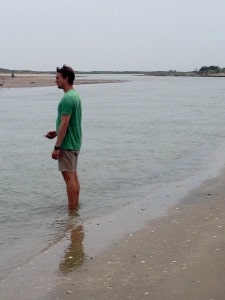
We left the car on the last few feet of paved road and started walking south along the Boca Chica Beach to Mexico. The few visitors that come here, usually head north to the jetty. We left that area for a future day-paddle from South Padre Island.
Boca Chica’s emptiness is its appeal
We passed no more than three cars in the first mile. Then, there was nothing but surf and dunes. The moist sand at the water line was covered with a carpet of shells and flotsam from offshore boats and ships.
Searching as we walked, an odd turquoise hunk of metal grabbed our attention. It was dotted with punch holes and standing upright right at the water’s edge. We tried digging it out and found it was the transom of a large sunken fishing boat. We marked the spot for later scavenging and moved on.
Camping and fishing far from the crowds
Farther south, we met one couple who had relocated from Washington. Now they lived in a RV park in Brownsville. The couple would come and stay on the beach for a couple of days, fishing, camping, and enjoying the isolation. They found it funny that we were walking towards the Rio Grande (sort of a reverse migration) and directed us to keep walking until we saw an old lighthouse tower in the distance.
 Was This A Signal?
Along the way, we spotted a pink folding chair high up in the dunes, placed in such a way as to survey comings and goings all around. Maybe a sign to cartel or coyote smugglers or a watch point for drugs floated in? It was so incongruous that our little adventure gained a whiff of intrigue.
Standing in the Rio Grande Looking Toward Mexico
Finally, around the next bend, we saw the top of the lighthouse framework. Eventually, the Rio Grande appeared. This river starts in Colorado and flows almost 1900 miles to end here as it peters across Boca Chica into the Gulf of Mexico.
Since so much water is diverted to agriculture by the time the river meets the Gulf, the Rio Grande on that visit was a very narrow “wash.” Hurricanes and heavy rains could quickly change this.
A disputed border
In the 1800s, there was heated disagreement between Mexico and the Republic of Texas on exactly where the international border was. Mexico marked the border at the Nueces River, which chopped off a big part of South Texas. Texans used the Rio Grande.
The dispute provided part of the rationale for the US invasion of Mexico in 1846, after Texas had become a US state. In 1848, the Rio Grande was recognized by both countries as the boundary between Mexico and the United States. This river also become important to both combatants in the US Civil War two decades later.
A boom town built by war
Time for a brief history refresher. Against the wishes of Sam Houston, Texas joined the Confederacy. That made the Rio Grande an escape route to Mexico for black slaves and Union loyalists living in Texas. Those loyalists included Northern sympathizers among German American residents of Texas Hill Country. Soon, Mexico was flooded by immigrants escaping war.

In the present day, we were standing in an isolated spot, cooling our feet in the shallow terminus of the Rio Grande River. Yet we were just steps from former site of an 1860’s Mexican boom town and commercial port called Bagdad. During the Civil War, this was the only legitimate port of the Confederacy.
But, when the Confederacy ceased to exist, so did Bagdad. The town itself was officially declared non-existent in 1880, and gradually erased by several hurricanes that covered any remaining evidence.
Backing away from the border
Now a flock of brown pelicans on the Mexican side outnumbered humans. After documenting that we had made it to the southernmost US/Mexico boundary, we hiked back along the beach, picking up some interesting items to re-purpose into coastal art.
We again passed the couple from Washington who offered us bottles of water. Finally, we got to the car for the return trip to South Padre Island…. with one more stop.
A town that never quite took root
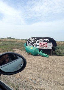
 Boca Chica Village, formerly Kennedy Shores and later Kopernik Shores is on the right. just north of the end of TXSH 4. Graffiti on a black water tank stands in for the city limits sign, almost obscured by a “for sale by owner” placard.
The settlement is adjacent to South Bay, a popular fishing spot for boats from South Padre island. We had forgotten this place was once a town until the speculation about SpaceX brought it back into the news.
Bad timing, bad weather
While historically, migration has been back and forth between Mexico, the town was originally built to attract working-class Polish migrants. At completion in 1967, there were originally 32 homes, a restaurant, and a public utilities system. Later in that same year, Hurricane Beulah migrated to the Rio Grande Valley and destroyed much of Kennedy Shores.
It was renamed Kopernic Shores after Nicolaus Copernicus in 1975. By 2008, only six people lived in what is now called Boca Chica Village. Not sure how many are there now but we found a couple of interesting, artistic homes and yards that felt a little like Marfa before it was discovered.
 An open window on the future
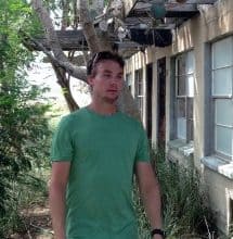
Our favorite find was crumbling, one-story motel. Cactus was growing through the roofs of the cinder block rooms and tearing apart the turquoise tiling in the bathrooms. Still, the motel was magical, and we imagined watching an eclipse or a meteor shower from its forgotten porch while “Hearts of Space” provided the soundtrack. Would Boca Chica become the launch point for immigration to another planet?
But first, take a trip back in time
Going to the beach today is vastly different from when we were kids. That’s a little sad. Nice to know you can learn some history while paying a short visit to the way things were back then by visiting Boca Chica Beach. But only if you hurry. The future is coming, even to this isolated stretch of the Texas coast.


